


Research - (2021) Volume 14, Issue 79
Received: Jun 16, 2021 Published: Aug 09, 2021, DOI: 10.17719/jisr.2021.4806
Tavşanlı Höyük is situated approximately 2 km from Tavşanlı District of Kütahya Province, and in the central part of the Tavşanlı Plain. The main objective of the Tavşanlı Höyük survey is to shed light onto the transition between the end of the 3rd Millennium BC and the 2nd Millennium BC. The purpose of the geo-archaeological research around the Tavşanlı Höyük was to reveal the influential factors in selection of the spot for founding the mound and the environmental changes that took place around the mound in time and space. For this purpose, vibracorings were done at three points on a line stretching from the alluvial fillings left by Orhaneli Stream flowing in the east to the mound. The preliminary results of our research seem eye-opener for in two ways. It revealed environmental conditions of Tavşanlı Höyük but also confirmed that the findspot is a prominent Bronze Age city in Western Anatolia. The settlement is likely to have been established as a city for the supply of natural resources around and transfer within the framework of the trade network.
Tavşanlı Höyük, Geoarchaeology, Bronze Age, Turkey.
The main goal of the Project of “Eskişehir and Kütahya Provinces Prehistoric Survey” (EKAR), which was incepted in 2017, is to conduct large-scale survey on big settlements by using modern techniques with the aim of filling the gap regarding problems and chronological gaps about the prehistoric times in the region. Besides the works carried out in this region using archaeological research methods, geo-archaeological methods are also being employed to explore the environmental changes of the settlements under survey. This article presents the preliminary results of the detailed surveys conducted on Tavşanlı Höyük.
Tavşanlı Höyük is situated approximately 2 km from Tavşanlı District of Kütahya Province and in the middle of Tavşanlı Plain (Fig. 1-2). The Orhaneli Stream, which flows right by the settlement, is the largest stream in the entire plain. The main objective of the Tavşanlı Höyük survey is to shed light onto the transition between the end of the 3rd Millennium BC and the 2nd Millennium BC. It is of great importance to figure out the status of the settlement during the 2nd Millennium BC and to detect the dates when it was abandoned. Although the abovementioned period constitutes one of the most important problems for pre-historic facts in Western Anatolia and corresponds to the time when city states began emerging in the region, it has been studied only too little so far.
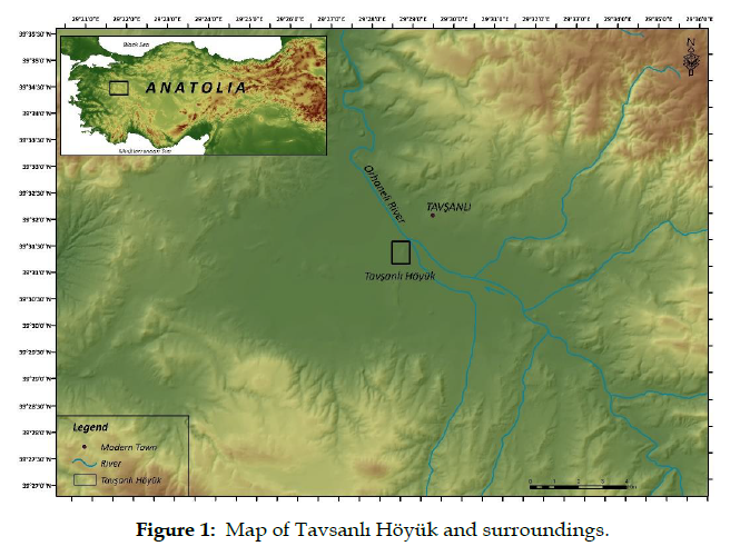
Figure 1: Map of Tavsanlı Höyük and surroundings.
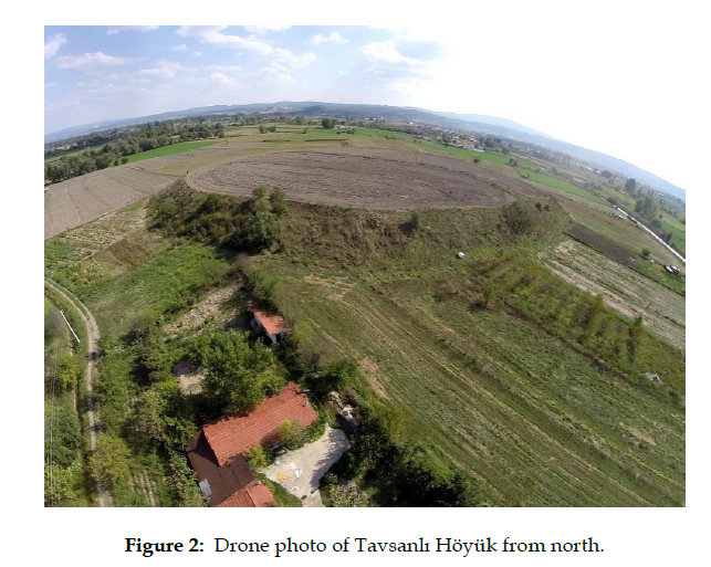
Figure 2: Drone photo of Tavsanlı Höyük from north.
On Tavşanlı Höyük, archaeological survey was conducted with the method called “intensive survey” (Fig. 3). Before starting, the mound and its surroundings were divided into 50 x 50 m squares on an area of 450 x 450 m. Archaeological materials were collected from 81 squares in total. But as it was seen that archaeological material continued beyond these squares, pottery was collected from other directions after numbering the west as 82, south 83, east 84 and north as 85. The Bronze Age material extends over an area of 650 m x 680 m, which hints at a settlement of approximately 44 hectares. The mound is 14 m above the current level of the plain.
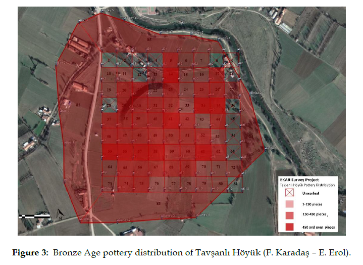
Figure 3: Bronze Age pottery distribution of Tavşanlı Höyük (F. Karadaş – E. Erol).
During the survey, pottery from the Early Bronze Age (EBA), Middle Bronze Age (MBA) and Late Bronze Age (LBA) was unearthed (Fig. 4 ). Also, pottery samples that might qualify to the Iron Age, few though, were spotted on the mound. Among black-topped bowls in particular, inward-oriented forms were outstanding dating to the Early Bronze Age. The other bowls had a simple profile. Transition to the Middle Bronze Age and Middle Bronze Age materials were concentrated on the slopes of the mound. Here were seen bead-rim bowls, which might belong to the Transition Period towards the MBA. Finally, pottery characterizing the Late Bronze Age was found on the top of the mound.
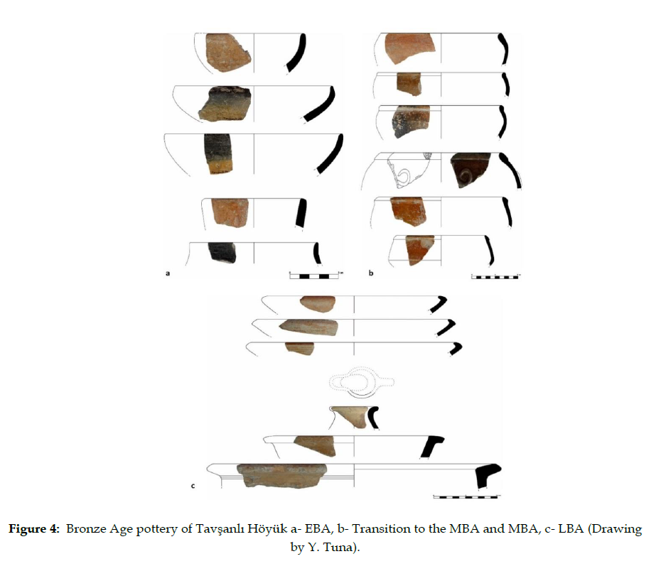
Figure 4: Bronze Age pottery of Tavşanlı Höyük a- EBA, b- Transition to the MBA and MBA, c- LBA (Drawing by Y. Tuna).
The purpose of the geo-archaeological research around the Tavşanlı Höyük was to reveal the influential factors in selection of the spot for founding the mound and the environmental changes that took place around the mound in time and space. For this purpose, vibracorings were done at 3 points (TVŞ 1, TVŞ 2, TVŞ 3) on a line stretching from the alluvial fillings left by Orhaneli Stream flowing in the east to the mound (Fig. 5). The drilling went down maximum 8 m (TVŞ 2); still, the ground or bedrock could not be reached.
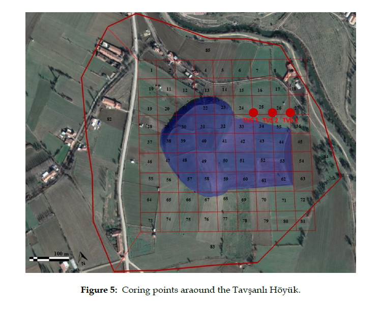
Figure 5: Coring points araound the Tavşanlı Höyük.
The corings were implemented by using a manually operated Atlas Copco drilling machine and sediment samples of alluvial fillings were taken by means of pipes with half-open end of (inner diameters: 5 cm and 6 cm) and 1,10 cm length (Fig. 6). Physical properties of the sediment like grain size and color were noted for sampling as appropriate for analysis. The archaeological materials found within the auger heads (e.g. ceramic, pieces of brick) and datable organic materials (such as charcoal and plant remains) were put in separate packages.
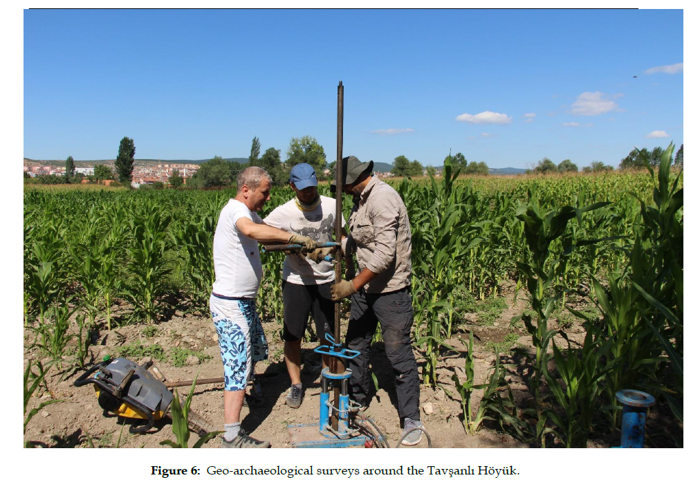
Figure 6: Geo-archaeological surveys around the Tavşanlı Höyük.
The first coring between Tavşanlı Höyük and Orhaneli Stream (latitude: 39 52 9918, longitude: 29 488517, altitude a.s.l: 822,5 m, depth: 3 m) was TVŞ 1. A layer of 30 cm on top of the drilled area was ploughing layer. Right under this layer, floodplain sediments appeared which were made up of light brown, clay-silt size materials and continued until the end of the drilling depth.
The pottery and brick fragments and charcoal remains found in these sediments demonstrated that the culture layer of the mound spread as far as into this area.
Next, coring TVŞ 2 was applied at the midpoint between Orhaneli Stream and the Tavşanlı Höyük (latitude: 39 53 0030, latitude: 29 487978, altitude a.s.l.: 824,5 m, depth: 8 m). Like in TVŞ 1, below the ploughing layer (upper 30 cm) existed typical floodplain sediments comprised of light brown clay-silt size materials. This unit persisted as deep as 360 cm and was rich in archaeological materials (ceramic, brick, pavement stone and bone fragments, charcoal pieces). The ceramic pieces represented typical gold-mica compounded Bronze Age pottery. Below the burnt layer from 360 to 380 cm, physical properties of sediments changed notably. From 380 cm downwards, not only the amount of clay contained in sediments increased but also its color turned into olive gray. A drastic reduction in the archaeological materials was seen within the unit. After a massive brick layer remaining from a building between 435 and 440 cm, the unit now gained a completely sterile structure. Going as far as 800 cm where drilling ended, the unit is thought to have been deposited in a back-swamp or shallow lake looking at the grain size and color and the intensive crop residues. Apart from these, a burnt ceramic piece found at 764 cm signifies existence of human beings in the surrounding (fig. 7).
Some of the samples taken from the burnt layers found in TVŞ 2 were processed with C14 dating at TÜBİTAK Marmara Research Center. As a result, five were identified as charcoal (samples 1 to 5) and one was terrestrial fossil (sample 6). The results of analyses and their calibrated ages along with the corresponding archaeological periods are given below:
1- 2500-2395 BC (Late EBA II- Early EBA III) at 1.3 meter below the surface (823.2 m.)
2- 2573-2466 BC (EBA II) at 1.9 meter below the surface (822.6 m)
3- 2680-2500 BC (EBA II) at 2.8 meter below the surface (821.8 m)
4- 2873-2620 BC (EBA Ib) at 4.8 meter below the surface (820.1 m.)
5- 3100-2925 BC (EBA Ia) at 6.1 meter below the surface (818 m.)
6- 6074-5988 BC (Late Neolithic) at 7.4 meter below the surface (817.1 m.)
The last coring, TVŞ 3, (latitude: 39 530146, longitude: 29 487411, altitude a.s.l: 824,2 m, depth: 7 m) similarly supplied light brown floodplain sediments starting below the ploughing layer containing abundant archaeological materials (ceramics, charcoal fragments, piece of stone and bone fragments). The unit showed a marked increase in burnt layers starting from 285 cm but a mud brick layer came into view between 355 and 360 cm. Under this layer, sediments take an olive gray color. Indicator of a back-swamp or shallow lake, this unit ended in a thick anthropogenic layer comprising of large and angular flints and limestones between 530 and 555 cm then sandstones from 555 to 600 cm. At the time of establishment of the mound, the banks of a back-swamp-shallow lake habitat in this neighborhood might have been filled by humans for anthropogenic use (Fig. 7).
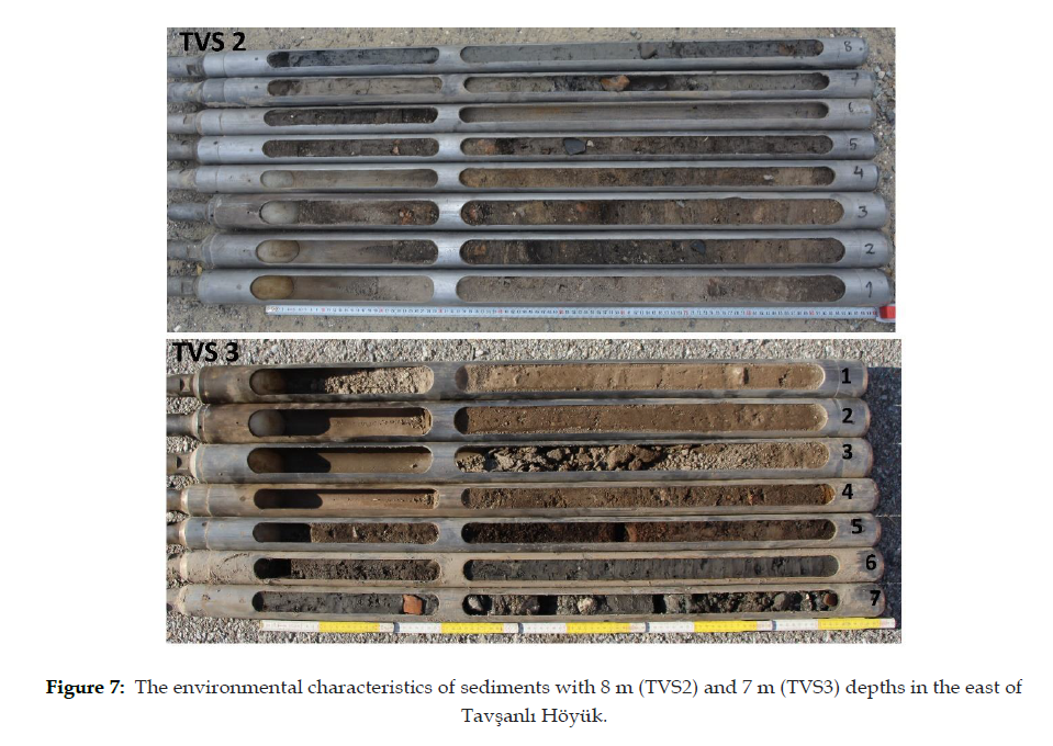
Figure 7: The environmental characteristics of sediments with 8 m (TVS2) and 7 m (TVS3) depths in the east of Tavşanlı Höyük.
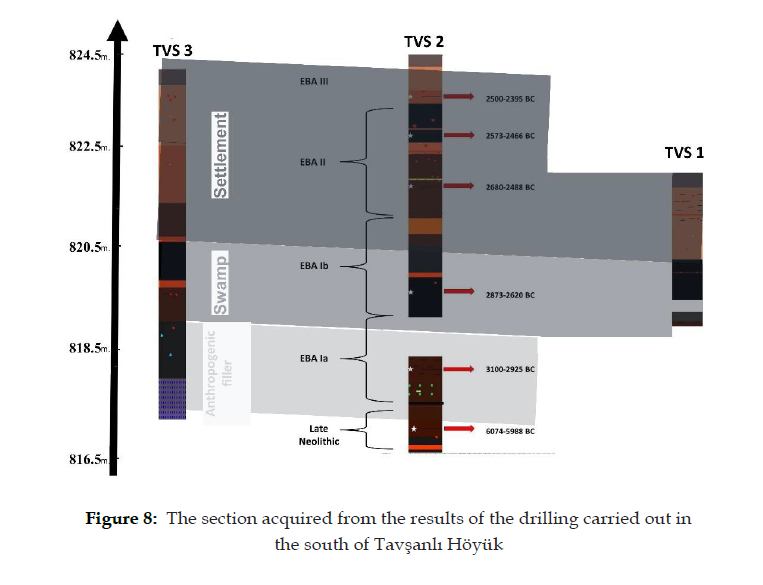
Figure 8: The section acquired from the results of the drilling carried out in the south of Tavşanlı Höyük
The archaeological surveys proved evidence that Tavşanlı Höyük is the one of the most important settlement dating back to the 2nd and 3rd Millennium BC in all of the West Anatolia. Drawing on the limited number of Iron Age materials found on the Tavşanlı Höyük heavily signify the Early Bronze Age, Middle Bronze Age and Late Bronze Age; it can be suggested that human settlement continued in the Iron Age too but did not survive up to day. As the other pillar of the survey, geoarchaeological investigations helped appraise the time-bound changes in the environmental conditions of the settlement. Moreover, thanks to the radiocarbon samples applied to the residuals picked with drilling, considerable steps have been taken in precise dating of a settlement studied with field survey.
The data obtained from the vibracoring works carried out on Tavşanlı Höyük during the first year testify to the existence of a back-swamp-shallow lake setting in the immediate vicinity of the mound during early years of the settlement (Fig. 8). Also, it is anticipated that the Neolithic settlement was built near this wet territory. The swamp-lake must have continued to exist during the following phases of the settlement. It was also found out that the dwellers on the banks of such a territory relatively close to the settlement filled these places in early 3rd Millennium BC (EBA I) (see the filling layer and C14 findings from TVŞ 3). Few, if any, archaeological residuals were located in the back-swamp-sallow lake vicinity and it can be suggested that the burnt layers there were generated from burning of reed bed on the bank, naturally occurred namely. Starting from 350-400 cm below the current surface, this marshy-lake environment must have been replaced by a culture layer deposited in the floodplain setting containing abundant archaeological materials and burnt layers. It implies that swamp draining works were successful during the EBA I and lively activities began for settling down around the mound upon the start of the EBA II. Archaeological materials largely found in the floodplain sediments looks to provide sufficient proof.
Furthermore, availability of very few EBA potteries on the surface despite the EBA filling of about 10 m was explained by geoarchaeological corings. The two thick burnt layers dating back to the second half of the EBA must have caused the pottery to remain locked underneath. Apart from these, the C 14 analyses here offered new data about the Neolithic Age with precise dating of living within that age. It is a new finding because previous surveys around Tavşanlı Mound furnished no remnants of this age at all and the same age was only partially uncovered at two or three sites within entire province of Kütahya. Additionally, all phases of the EBA were identified with radiocarbon dating performed in this research.
The preliminary results of our research seem eye-opener for in two ways. It revealed environmental conditions of Tavşanlı Höyük but also confirmed that the findspot is a prominent Bronze Age city in Western Anatolia. The settlement is likely to have been established as a city for the supply of natural resources around and transfer within the framework of the trade network. It can be confidently argued that archaeological excavations will bring about noticeable implications for Anatolian archeology by means of new findings and information

The Journal of International Social Research received 8982 citations as per Google Scholar report